Georhena catalogue
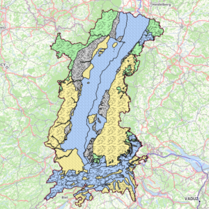
Hydrogeology: Upper Rhine aquifer
Location of the Upper Rhine aquifers according to the type of rock medium (porosity) and yield. The latter reflects the amount of water or flow that can be extracted from the groundwater contained in the aquifer. It is categorised as follows: a few litres/s = low yield; ~10 l/s = medium yield; above 10 l/s = high yield.
Simple
- Date (Creation)
- 2021-11-15
- Date (Publication)
- 2021-12-15
- Citation identifier
- aquiferes_grundwasserleiter
- Status
- Completed
- Point of contact
-
Organisation name Individual name Electronic mail address Role GeoRhena
GeoRhena
GeoRhena
Point of contact Association pour la Protection de la Nappe Phréatique de la Plaine d'Alsace (APRONA)
Processor Water Resources Expert Committee
Originator Landesanstalt für Umwelt Baden-Württemberg (LUBW)
Custodian Regierungspräsidium Freiburg -Gewässer und Boden (RPF-GB)
Custodian Regierungspräsidium Freiburg - Landesamt für Geologie, Rohstoffe und Bergbau (RPF-LGRB)
Custodian Landesamt für Umwelt -- Rheinland-Pfalz (LfU –RP)
Custodian Struktur- und Genehmigungsdirektion Süd Rheinland-Pfalz (SGD-Süd-RP)
Custodian Amt für Umweltschutz und Energie, Basel-Stadt (AUE-BS)
Custodian Région Grand-Est (RGE)
Custodian Direction Régionale de l’Environnement, Aménagement et du Logement (DREAL)
Custodian BRGM Service Géologique Régional d’Alsace (BRGM)
Custodian Association pour la Protection de la Nappe Phréatique de la Plaine d'Alsace (APRONA)
Custodian Landesamt für Geologie und Bergbau Rheinland-Pfalz (LGB-RP)
Custodian Amt für Umweltschutz und Energie, Basel-Landschaft (AUE-BL)
Custodian
- Maintenance and update frequency
- Not planned
- Keywords
-
-
Open-Data
-
water
-
- Place
-
-
Upper Rhine
-
-
GEMET - INSPIRE themes, version 1.0
-
-
Hydrography
-
-
GEMET - Concepts, version 2.4
-
-
hydrography
-
groundwater
-
water table
-
- Use limitation
-
CC BY Licence
- Access constraints
- Other restrictions
- Use constraints
- Other restrictions
- Other constraints
-
No other limitation
- Spatial representation type
- Vector
- Denominator
- 25000
- Language
- Français
- Character set
- UTF8
- Topic category
-
- Inland waters
- Begin date
- 2021-01-01
- End date
- 2021-12-31
))
- Distribution format
-
Name Version SHP GeoData
-
- OnLine resource
-
Protocol Linkage Name OGC:WMS
https://geoportal.georhena.eu/geoserver/water/ows aquiferes
OGC:WFS
https://geoportal.georhena.eu/geoserver/water/ows water:aquiferes
WWW:DOWNLOAD-1.0-ftp--download
https://geoportal.georhena.eu/geoserver/water/ows?request=GetFeature&service=WFS&typeName=aquiferes&version=1.0.0&outputFormat=SHAPE-ZIP Téléchargement du Shapefile Téléchargement du Shapefile
- Hierarchy level
- Dataset
- Statement
-
APRONA + GeoRhena - 2021
Metadata
- File identifier
- bb8f8b39-406b-4fff-b306-2aa086a2234f XML
- Metadata language
- Français
- Character set
- UTF8
- Hierarchy level
- Dataset
- Date stamp
- 2022-09-14T07:51:29.264186Z
- Metadata standard name
-
ISO 19115:2003/19139
- Metadata standard version
-
1.0
- Metadata author
-
Organisation name Individual name Electronic mail address Role GeoRhena: Geographical Information System of the Upper Rhine
Distributor
- Other language
-
Language Character encoding German UTF8 English UTF8 French UTF8
)))